

During January 2021, I am participating in Age UK’s ‘Run Your Age’ event by running a total of 51km. It would be great if you would SPONSOR ME to raise funds to support older people in Lincolnshire and across the UK!
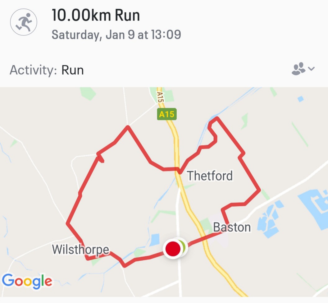
On Sat 9th Jan, I ran through Wilsthorpe, Obthorpe and across to Baston in a loop of 10km bringing my ‘running total’ to 33km.
My run started on King Street which is a Roman road which dissects the County Council Division of ‘Deepings West and Rural’. I first followed a footpath across a field of beet to a bridge over the River Glen, in fact the first bridge after the West Glen merges with the East Glen. This brought me into the small village of village of Wilsthorpe (formerly Wivelestorp) which comprises only forty houses including two farms.
At the centre of the village is the church of St Faith of Acquitaine, Wilsthorpe. Due to Covid, the church was not open but I had visited once before when I attended a meeting of Braceborough and Wilsthorpe Parish Council which uses the church in the absence of any other appropriate meeting place in the village. I remember it being quite cold and gloomy (the church, not the Parish Council) but it was, as I recall, a winter evening.
St Faith’s church is one of the smallest in the area as well as the youngest church in the Uffington benefice, being only 300 years old. The tercentenary was celebrated in 2015 with a service led by the Bishop of Lincoln.
It was built in the 18th century, a fine example of early Georgian but in 1863 the building was altered by architect James Fowler which resulted in a Classical & Gothic mash-up.
If Dan Brown ever makes a sequel to the Da Vinci code set in rural Lincolnshire, then St Faith’s church might be a good place to start. The stained glass above the altar would be right up his street while the ancient grafitti carved into the front of the building would give him plenty to think about.
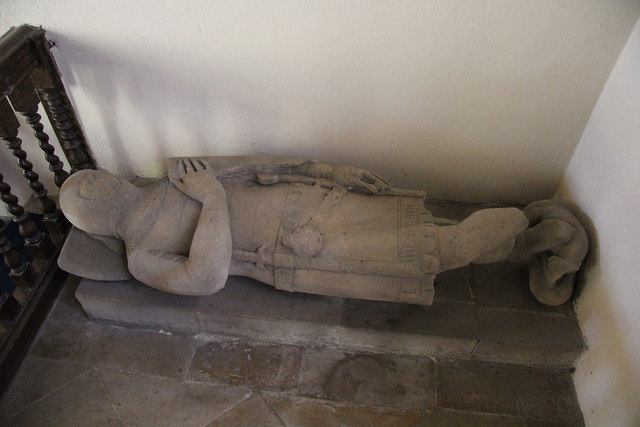
Despite being only 300 years old, the church has somehow acquired a fine and authentic stone figure of a 13th century knight bearing a shield with the arms. It is thought to be that of the Wake family but this has not been proven. Hereward the Wake was an Anglo-Saxon originally from the Bourne area who led resistance to the Norman invasion & became known as ‘Hereward the Outlaw’ and ‘the last Englishman’ because he held out against the occupying army until 1081. The Wakes are remembered fondly in and around our area with a road in Market Deeping named after Joan Wake and, when I was young, there was a radio station at the other end of the fens named after Hereward. The car stickers used to read “Hereward is a-wake!” which I thought was quite clever even if the pun had been over 900 years in development.
At the end of 2016 the church steeple was repaired to stop ingress of rain and pigeons. This was funded by grants from various organisations and fund-raising withisin the village, including Open Gardens and a ‘Pimms and Plants’ evening, which is now an annual event!
Wilsthorpe was also known for providing Peterborough (14 miles away) with gallons of water each day after a 52ft deep well was drilled in the 19th Century.

Shortly after passing the church my route converged with the Macmillan Way which is one of a small number of long distance walks which takes a route through South Kesteven. The path ahead therefore led towards Boston while the path in another direction could have taken me over 200 miles to Abbotsbury in Dorset! I ran past a total of three people before leaving the village to the North towards the hamlet of Obthorpe. I was a bit surprised to be confronted with a very slight incline. The first since I started this month’s running challenge and possibly the last.
I continued on the Macmillan Way across the a15 at Kate’s Bridge which, for centuries if not millenia, has been a point of interest on the route between Peterborough and Lincoln. It would have been the point at which traffic crossed the aforementioned King Street Roman road met the River Glen and the nearby ‘Thetford’ suggests there was a ford there. By the 13th century it was known as ‘Caterbrig’ suggesting that a bridge had been established. The current bridge was built in the 19th century as part of the turnpike route. Travellers can still refresh themselves at the nearby filling station which now sells petrol.

Kate’s Bridge is also the point at which King Street meets Car Dyke which is another construction of the Roman era which eight-five miles along the western edge of the Great Fen. The origin and purpose of the Car Dyke are a mystery, but it is generally accepted as marking the western edge of the Fens. To the South it runs through the middle of Market Deeping, roughly along the course of Godsey Lane.
Baston village has a church, a primary school as well as Kirkstone House private school. It is divided by the busy A15. I was particularly grateful for the footpaths because I have previously tried to run alongside the A15 towards Kate’s bridge but the lack of footpath provision makes it very dangerous.
The River Glen to the East of the A15 was particularly picturesque as I ran. After about a kilometre, I turned to the South towards Baston entering that village via a footpath adjacent to the cemetery.
After Baston, my route wend its way back onto King Street completing the loop and the run.

Kates Bridge used to be the head of navigation up the River Glen from the sea. Goods would be offloaded and put on small lighters where they could carry on their journey to Greatford, and vice versa.
The old Roman Ford can still be seen if you know where to look.
The river bed between the old and the new bridge is full of fossils.
Frankie Vaughan used to own the fishing rights at the mill upstream of Kates Bridge.
The village of Thetford used to belong to Spalding Abbey, and once had a chapel and priests to attend to the people there.
Pingback: What about the ‘rural’? | DeepingDo – The blog of Ashley Baxter, Independent Councillor and founder member of the Deepings Rebel Alliance!